Digital Map Gallery
2025 Submissions
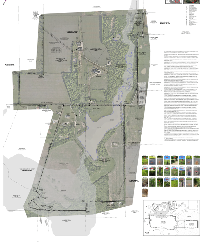
Boundary survey CIRCA 2025
1u
Robert Young
Boundary survey CIRCA 2025
1u
Robert Young
Description:
Current best practice delivery of boundary survey data to date from our team.
Purpose:
Create a tool of conveyance and estate planning for land owner.
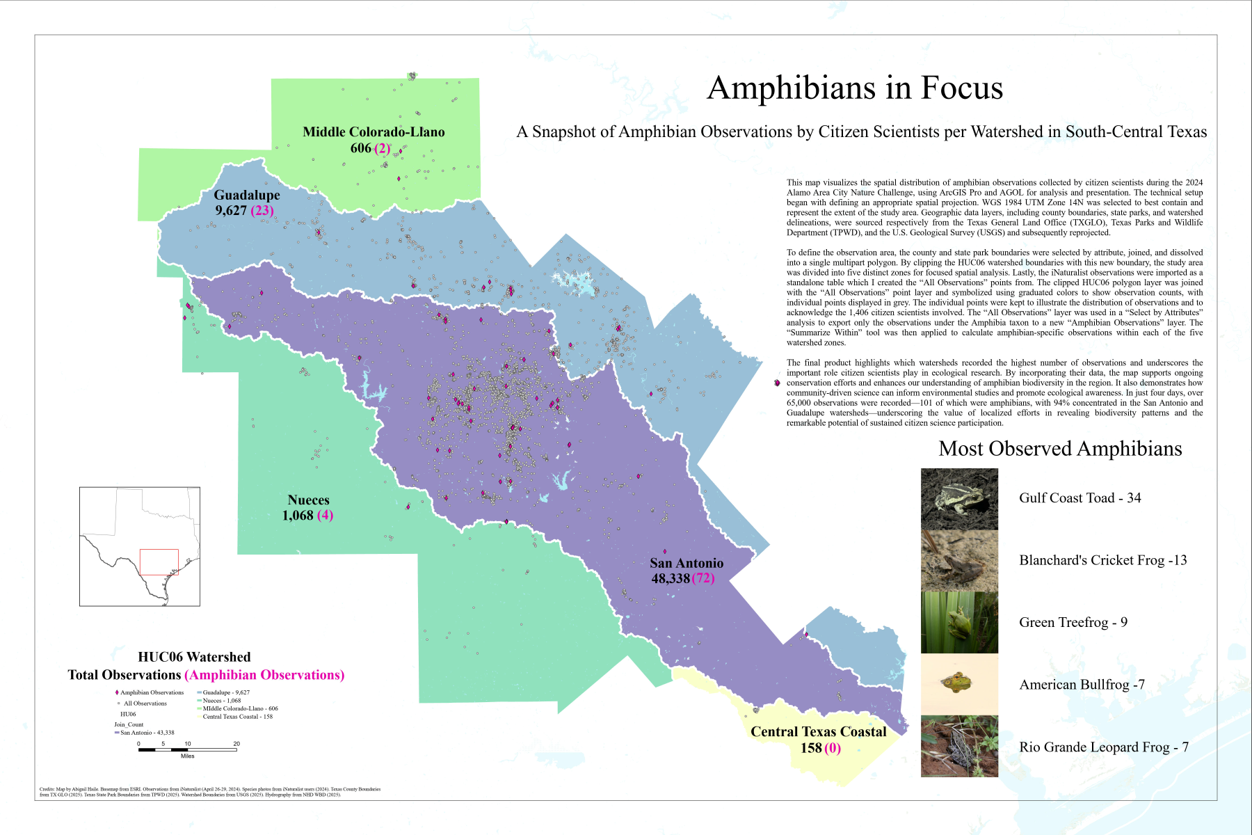
Amphibians in Focus
2p
Abigail Haile
Amphibians in Focus
2p
Abigail Haile
Description:
Layout with detail and inset locator map
Purpose:
To display citizen science amphibian observations per region
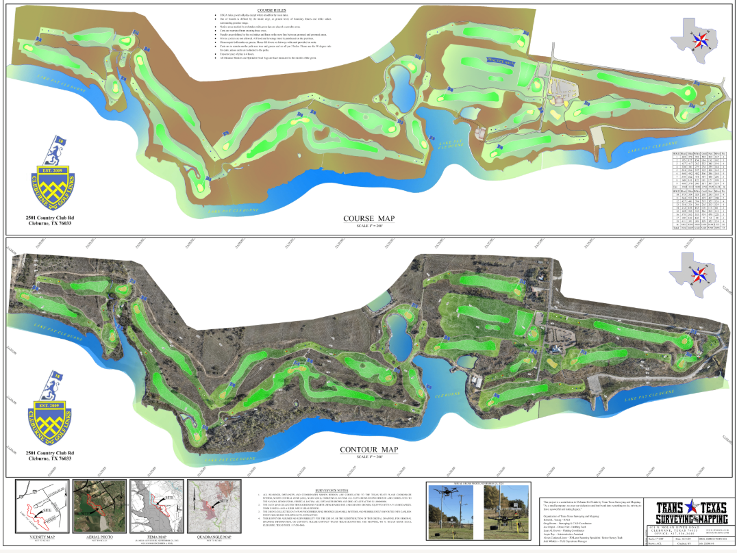
Cleburne Golf Links
3e
Robert Young
Cleburne Golf Links
3e
Robert Young
Description:
2024 map of Cleburne Golf Links, Cleburne, Texas showing location and relief information with opaque high resolution orthophoto and contours, collected with aerial lidar and camera sensors using DJI M300 with P1 35 mm 48 megapixel camera and RIEGL mini 3 lidar sensor on a Harris 6E aerial platform.
Purpose:
Provide current map of the course for the City of Cleburne, while using our RIEGL scanner for the first time. Our goal was to provide a valuable product to the City as their current maps were outdated.
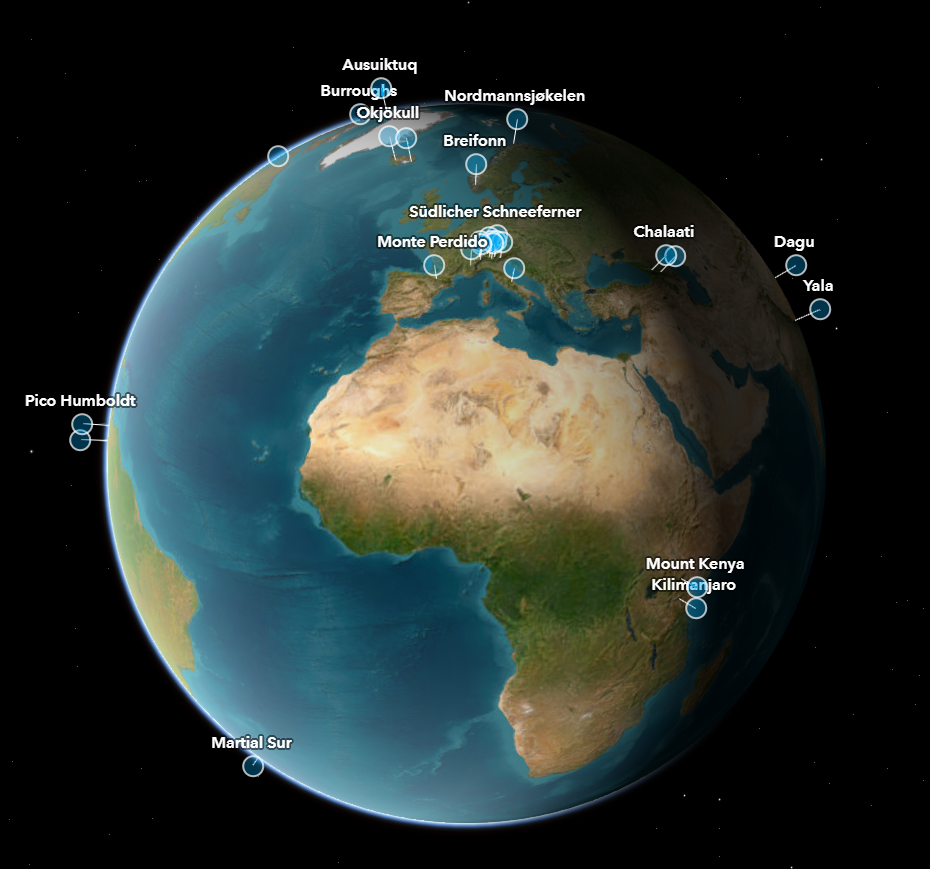
Global Glaciers Casualty List
4l
Bruno De Castro Sousa
Global Glaciers Casualty List
4l
Bruno De Castro Sousa
Description:
The Global Glacier Casualty List (GGCL) is a dynamic platform to visualize data about recently disappeared and soon-to-disappear glaciers. We want to tell these glaciers’ stories and how their losses have or will impact human communities in terms of cultural meaning, natural beauty, water availability, economic opportunity and world heritage.
Purpose:
Help spread the word about the dire situation of glaciers around the globe.
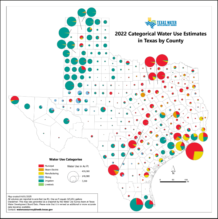
2022 Categorical Water Use Estimates in Texas by County
52
Kelli Condina
2022 Categorical Water Use Estimates in Texas by County
52
Kelli Condina
Description:
This map provides a snapshot of water use by category and the proportionate use by county for 2022 (most recent year available). The size of the pie charts indicates the overall volume of water usage, and the different categories of the pie chart (irrigation, livestock, manufacturing, mining, steam electric and municipal) break down how much water is being utilized in each different use category.
Purpose:
This map is hosted on the TWDB website to provide public access to data collected and analyzed by the Water Use Survey team. It offers insights into how water usage is across the state. It shows the volume of water used in each county. Additionally, the map categorizes the water usage into different types: irrigation, livestock, manufacturing, mining, steam electric and municipal. This breakdown allows for a better understanding of how water is utilized in each county.
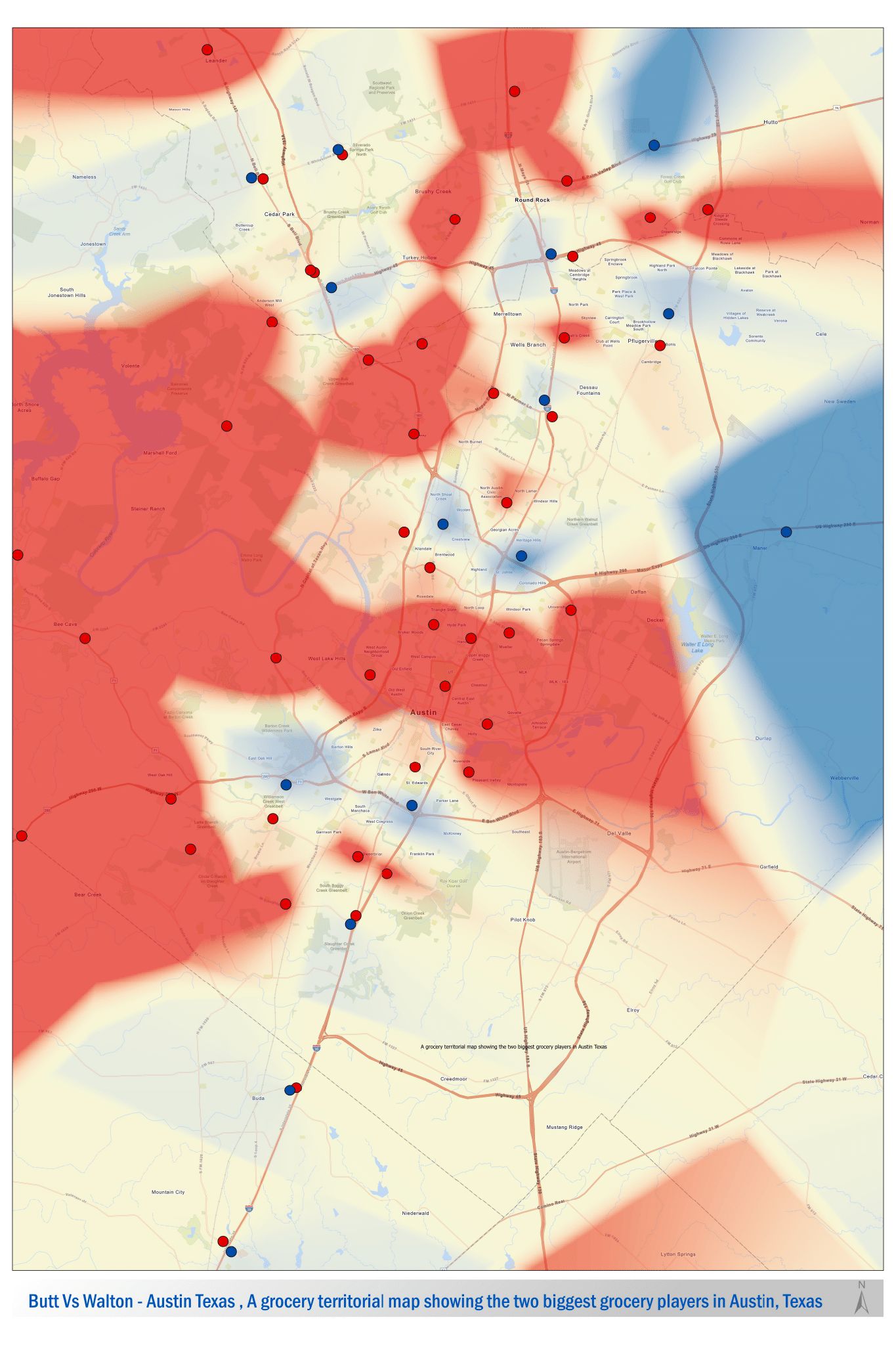
Butt Vs Walton
6t
Matthew McCracken
Butt Vs Walton
6t
Matthew McCracken
Description:
A grocery territorial map showing the two biggest grocery players in Austin, Texas
Purpose:
Show users a territorial analysis.
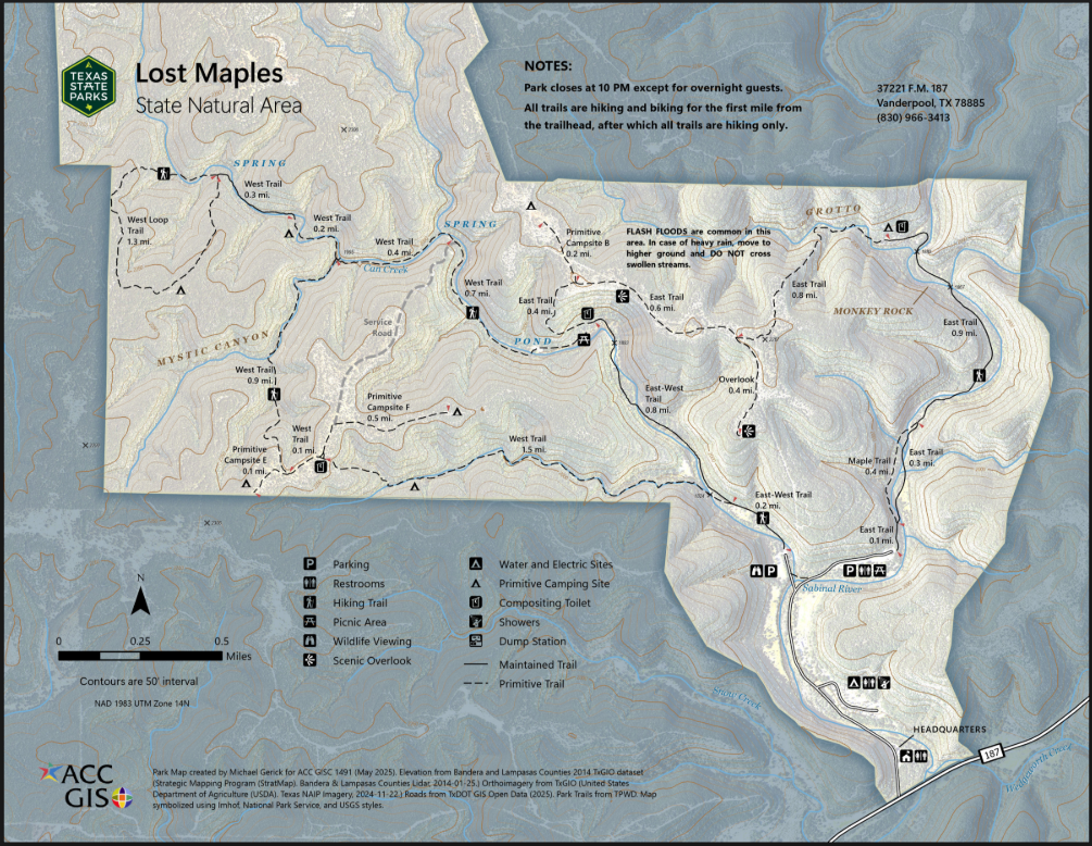
Lost Maples State Natural Area Map
7s
Michael Gerick
Lost Maples State Natural Area Map
7s
Michael Gerick
Description:
A general reference map for park visitors. Includes amenities, natural features, and elevation.
Purpose:
Practice cartographic techniques for symbolizing surfaces, layering rasters, and working with annotations in ArcGIS Pro.
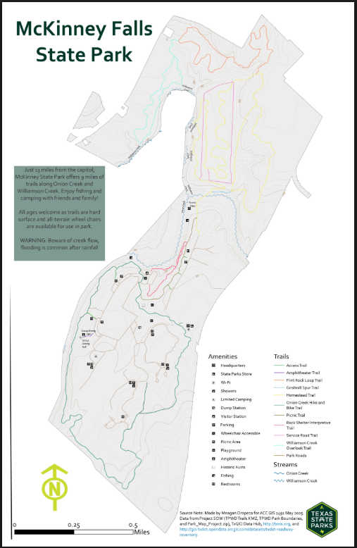
McKinney Falls State Park Trails Map
8K
Meagan Oropeza
McKinney Falls State Park Trails Map
8K
Meagan Oropeza
Description:
User friendly trails map of McKinney State Park.
Purpose:
Assignment for Cartography course at ACC (GIS 1491)
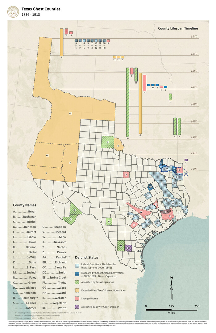
Texas Ghost Counties
9x
Weatherly Sawyer
Texas Ghost Counties
9x
Weatherly Sawyer
Description:
This map displays historically defunct or abandoned counties in Texas. Our intern, Weatherly, and our Historian performed a significant amount of research and collaboration to visualize this information. They developed a way to symbolize and label historical boundaries along with modern-day and illustrate how these phenomena changed over the given timespan.
Purpose:
This map is based on TEKS curriculum and will be provided by our educational outreach coordinators to teachers across the state to be used in middle school classrooms.
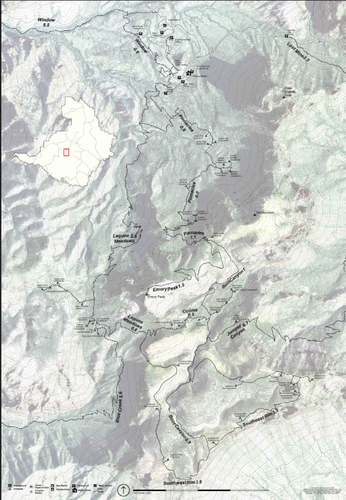
Big Bend: Chisos Mountains Trails
10g
Johnathan Allan
Big Bend: Chisos Mountains Trails
10g
Johnathan Allan
Description:
Map of the Chisos Basin area in Big Bend National Park, featuring trails, roads, and visitor facilities.
Purpose:
This map was created in response to a request from a client who is an avid hiker. It is designed to help them navigate the Chisos Basin area of Big Bend National Park by clearly showing trail routes, nearby facilities, elevation changes, and trail distances, ensuring a safe and well-prepared hiking experience.
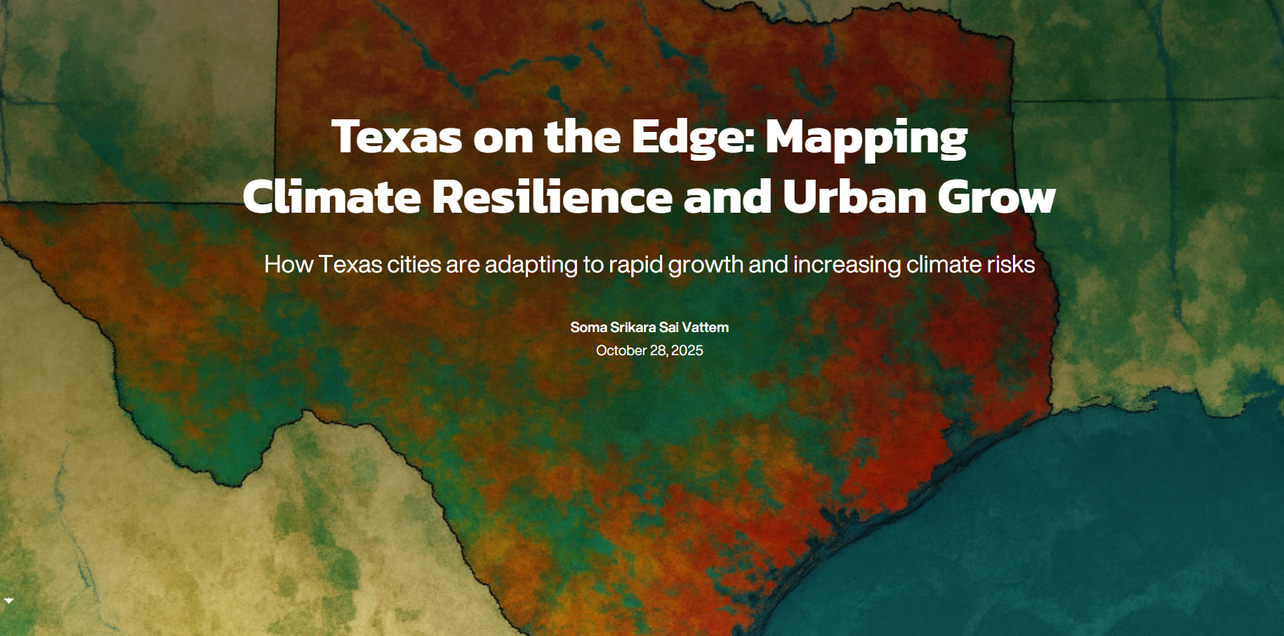
Texas on the Edge: Mapping Climate
Resilience and Urban Grow
11x
Soma Srikara Sai Vattem
Texas on the Edge: Mapping Climate
Resilience and Urban Grow
11x
Soma Srikara Sai Vattem
Description:
This StoryMap visualizes environmental and demographic patterns across Texas, focusing on the state’s rivers, flood-prone areas, urban heat distribution, impervious surfaces, and population density. It combines data from national sources to highlight how natural and built environments interact in shaping resilience and sustainability.
Purpose:
The purpose of this map is to raise awareness of how Texas’s water systems, land use, and urban growth influence flood risk, heat exposure, and community planning. It supports data-driven decision-making for climate adaptation, infrastructure planning, and sustainable development initiatives.
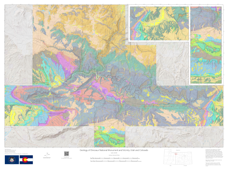
Geology of Dinosaur National Monument
and Vicinity, Utah and Colorado
12e
Thomas Brown
Geology of Dinosaur National Monument
and Vicinity, Utah and Colorado
12e
Thomas Brown
Description:
Geologic map of Dinosaur National Monument showing stratigraphy, geologic structures, topography, hillshade, hydrology, political boundaries, and cultural features. This map was developed from a USGS-NPS dataset that is part of a series showing the geodiversity of national parks and monuments.
Purpose:
Geologic map developed for instructional and display purposes. The instruction purposes are for geology laboratories covering geologic maps, stratigraphic relationships, and geologic structures.
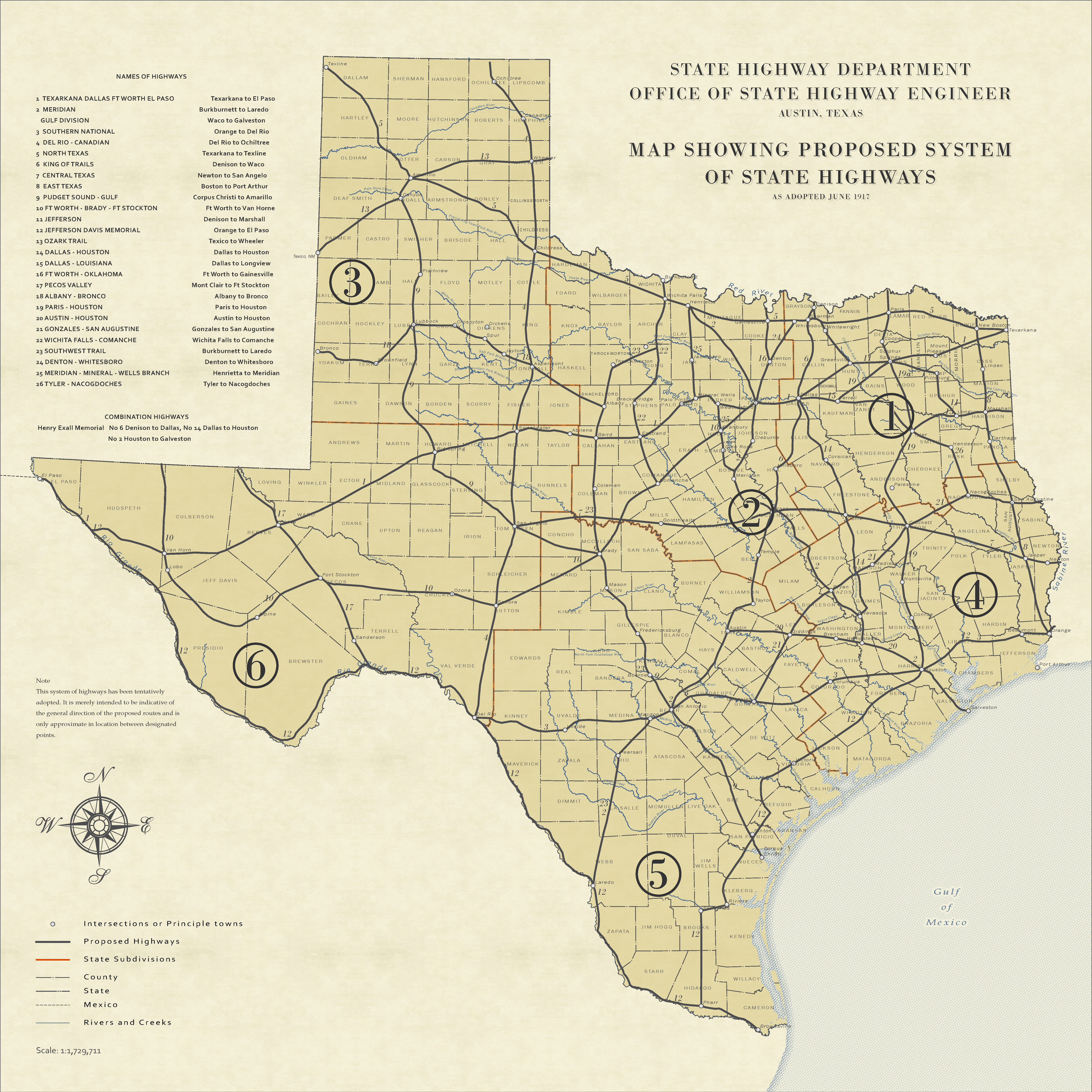
Proposed Highways of 1917
13r
Tom Neville
Proposed Highways of 1917
13r
Tom Neville
Description:
The digital map was created using ArcGIS Pro. A scanned TIFF file of the original map was georeferenced by matching known locations on the image with corresponding points from several feature layers. The proposed highways, administrative divisions, and cities were then manually digitized using the Create Line tool. Finally, the completed map was exported as a PDF.
Purpose:
This 1917 map represents TxDOT’s bold vision for a modern transportation network. Created by what TxDOT was know as then, State Highway Department, it outlines a proposed system of state highways designed to connect cities, towns, and rural communities across the vast landscape of Texas. Notice the numbered districts and the detailed table of highway names—these reflect the early administrative structure for managing road development. The numbered lines show planned routes, marking the first steps toward a unified system that would transform travel, commerce, and daily life. Displayed here, the map is more than a technical plan—it is a snapshot of ambition at a time when automobiles were reshaping society. It invites viewers to imagine Texas before interstates and to appreciate how this proposal laid the groundwork for the highways we rely on today.